
- Startsida
- En
- Experience
- Nature and the outdoor life
- Hike in scenic Simlångsdalen
Hike in scenic Simlångsdalen
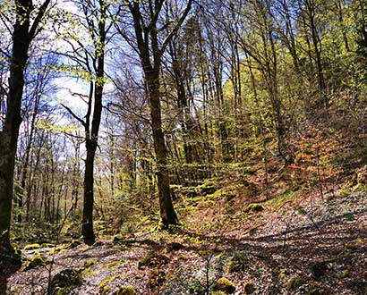
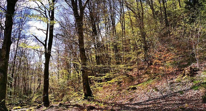
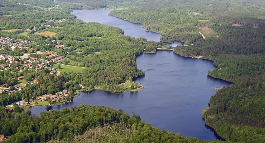
In the eastern reaches of Halmstad you will find Simlångsdalen, with its incredibly beautiful nature. In addition to several nature reserves, there are about ten hiking trails that wind their way through unspoiled nature, along beautiful lakes and through magical, fairytale forests.
The hiking area is divided into a northern hiking area that starts at the old Simlångsgården farm in Gyltige and a southern area where most hiking trails are accessed from the bathing area of Brearedsjön lake, adjacent to Vargaslätten garden. In addition to the hiking trails below, the Hallandsleden trail also runs through SImlångsdalen.
Map
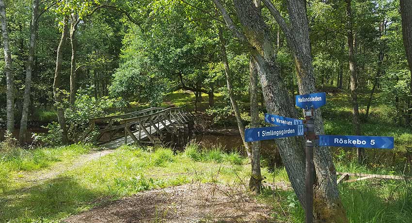
On naturkartan.se you can view digital maps of the hiking trails and nature reserves in Simlångsdalen (Swe). External link, opens in new window. A few selected ones are described further down the page.
The Simlången Circuit
The Simlången Circuit – BLUE 8 km
The eastern end of the trail runs through the Bröda (Swe) External link, opens in new window. and Veka nature reserves External link, opens in new window. in semi-hilly terrain with beautiful beech forests and seas of white wood anemones in the springtime. In the far north, the trail rounds the old Mahults Herrgård estate, which is fictionalised as Marsjö Gård in Fredrik Ström’s book Folket i Simlångsdalen (The People from Simlångs Valley). Where the trail turns off onto the old embankment for the Bolmenbanan train, there stands an old red-painted mill that belonged to Mahults Herrgård. From the embankment, a road leads down to Nybygget Mill. The entire western end of the trail runs along the old embankment. In the far south is the old bridge known as Hjärtevadsbron, and just before the bridge there is a hill called Drömkullen.
How did Hjärtevadsbron bridge and Simlången get their names?
“Once upon a time, there lived at Mahults Herrgård a knight named Ulv. He had only one child, a girl, and she was the friendliest person in the entire district. So you can understand that a great many knights were competing for her hand. But she gave her heart to none of them, saving it instead for a fisherman’s boy who lived by the lake. When Sir Ulv learned of this, he became enraged and his daughter wept and grieved until her father gave in. The fisherman’s son and the noblest of the knights had to compete for her hand in marriage.
From the bridge on the knight’s estate, the fisherman’s son would swim down to the Drömmarnas kulle (“the Hill of Dreams”), on the other end of the lake. The knight would ride to the same spot along the beach. The first contestant to reach the summit of Drömmarnas kulle would be declared the victor. The fisherman’s son arrived first, but when he got out of the water and quickly ran to the top of the hill, his heart stopped from sheer exhaustion. That is why the bridge is called Hjärtevadsbron (‘Heart’s Bet Bridge’) and the lake is called Simlången (‘the Swimming Length’).”
From Folket i Simlångsdalen by Fredrik Ström
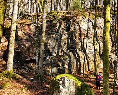
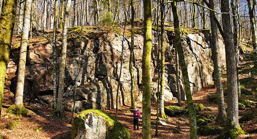
Klövaberget
Klövaberget Mountain – BLUE 0.7 km
Standing atop Klövaberget mountain’s 30 metre-high, 100 metre-long cliff wall is not for the faint hearted. At the summit you can hike through a beautiful beech forest. The mountain is named after its two cliffs, one in the north and one in the south, which together form the shape of a hoof (klöv in Swedish).
Anyone who instead chooses to enjoy this fault line from its foot can discover a 6 metre-wide cave. Climb inside and be enchanted! The forces of nature have also created the smooth boulders below the mountain. In the 13th century, stones for the church in Breared were collected here and the mountain was dubbed kyrkokleven, “the church cleft”.
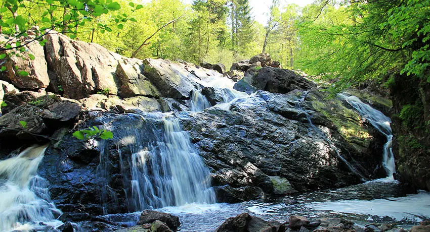
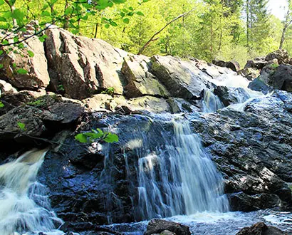
Danska fall
Danska Fall – BLUE 2.7 km
Danish Fall was named shortly after the Battle of Fyllebro in 1676, when the Swedish army trounced the Danish army. The surviving Danish soldiers fled down the Fylleån and Assman rivers, going as fast as they could. At the Danska Fall waterfall the inhabitants of Breared had built a rope bridge, and there the fleeing soldiers plummeted to their deaths.
On your way to the waterfall you will pass the Jöransfors ironworks and tannery, which belonged to Stjärnarp Manor and was one of Halland’s largest industries from 1730 to 1750. On the way to the fall, you will also pass Prästafallet waterfall, which you can read more about under the Brearedsjän Lake Circuit, which also passes Prästafallet. This trail is not yet described on the map above.

Smedhultaleden
The Gårdshult and Smedhultaleden trails
The Gårdshultleden trail – RED, 6.5 km
On this circuit you can choose to walk along the west or east side of the Assman river. There are also three detours if you wish to go further: The Brearedssjön Lake Circuit, the Smedhultleden trail and the Kannesten Circuit. The trail goes past Danska Fall and on to Gårdshult’s enchanting nature reserve. External link, opens in new window. The Hallandsleden trail also connects to the Gårdshultsleden trail.
Along the way, you will pass the stately pillar formation of a fault line. It has been called the Stenkyrkan (“the Stone Church”) since at least the beginning of the 19th century, when churches began to have church towers. There are many cracks in the pillar and it is not advised to clamber around on it.
On the western side of the Assman river lies Smedhultatorpet, a croft which belonged to Eriksköp village. The last people to live on the croft were Bengt and Botilda Bengtsson, who moved to the neighbouring village of Gårdshult in 1860. If you look around the croft, you can still find brick remains from the fireplace in the kitchen.
Smedhultaleden trail – BLUE/WHITE 4 km
In the Gårdshult Nature Reserve External link, opens in new window. you can walk along the Smedhultaleden trail. The trail is blue-white, but marked with a brown colour in the map above. Along the trail you will encounter Halmstad hill, a vantage point offering sweeping views of Halmstad. In clear weather, you can see all the way to the water tower in Söndrum. In the western part of the reserve is Uppbjär, the highest point on the Smedhultaleden, with a magnificent view of Halmstad and towards Gårdshult. When the surveyor DG Löhr established the boundaries between the villages of Gårdshult and Eriksköp in 1820, he called Smedhultamyren “Uppbjärs mosse” (“the Uppbjär peat bog”).
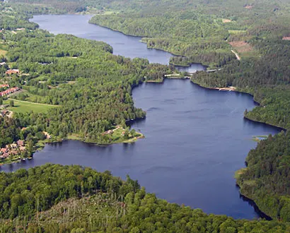
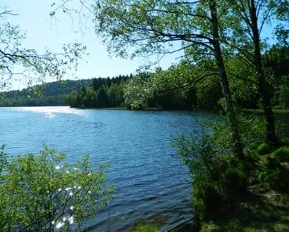
The Brearedssjön Lake Circuit. Photo: Thomas Johansson, Vinnalt
The Brearedssjön Lake Circuit – YELLOW 4.2 km
This hiking trail wraps around Brearedsjön lake, with beautiful beech forests on one side and the disused Bolmenbanan railway on the northern side. No train has chugged along these tracks since 1966. You will also pass the old Jöransfors iron works along the way.
Prästafallet waterfall and Pastor Jöran Friis
When you pass the river Assman, you will also pass Prästafallet waterfall. In the 1660s, the priest Jöran Friis ran Breared’s milling operations near a bridge upstream from the waterfall. In Halland’s history from 1820 you can read the following about the priest: “Jöran Friis was pastor during the Danish period, and had previously been a pastor at Jutland but had fallen out of favour and as a result received transport to Breared. After some time here, he was deemed to be far too devoted to Catholic teachings, and could not be persuaded to set aside the so-called ‘Red Book’. Too inclined to interfere in state affairs, Jöran Friis was removed from Breared’s pastorate.”
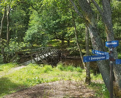
Hjärtevadsbron
When you return to the car park, you will cross Hjärtevadsbron (“Heart’s Bet Bridge”), which is said to have been named after a bet. You can read more about the betting under the Simlången Circuit, which also passes the bridge.
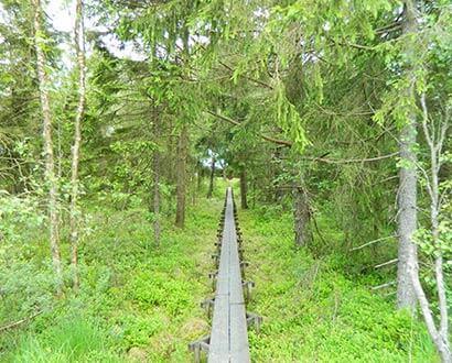
Gyltige’s hiking trails in Halmstad. Photo: Åse Ahlstrand
Gyltige’s four hiking trails
Gyltige was an agricultural property purchased in 1944 by Friluftsfrämjandet i Halmstad. A purchased military barracks initially served as a meeting point, but the barracks soon became too small as the visitors were numerous and there was a great deal of activity. By 1950, a larger and more suitable cabin had therefore been built. The cabin was very well visited all year round and soon this too seemed too small. By 1956, the construction of the “Simlångsgården” resort was started only to be inaugurated by the county governor Reimer Johansson in 1957.
As early as the 1950s, a handful of hiking and skiing trails were established, starting from Gyltige and Simlångsgården. A simple ski lift (rope lift) served daring skiers on the ski slope down towards Gyltigesjön lake. The ski lift is no longer there, but most of the hiking trails have now been renovated and marked in the terrain.
Gyltige – YELLOW 3.2 km
The yellow trail runs along paths and forest vehicle tracks north of Gyltige. On the western part of this hiking trail, steep-sided ridges are clearly visible. These are made of stone, gravel and sand and were left by the melting ice some 12,000 to 13,000 years ago. The terrain is pockmarked with large and small kettle holes left behind by the melting ice. Old gravel pits are witnesses to material having been taken for the construction of nearby houses and roads.
Gyltige – GREEN 11.3 km
The green trail runs northward from Gyltige along paths and forest vehicle tracks. If you choose to start with the western part of the trail, you will pass both pebble ridges and flat areas where large amounts of rock, gravel and sand were deposited during the last ice melting about 12,000–13,000 years ago.
The flat areas between Bårared and Rösekbo have been used as agricultural land for many generations. If you are lucky, you may see cranes, wild geese and other game.
Just west of Bårared lies Ryaberg, which for many years was a local centre for trade and communications. When Ryaberg Station and the narrow-gauge railway were still in operation (1889–1966), Ryaberg was home to several shops, timber traders and a dairy.
Many years ago, the railway in Röskbo was the site of a serious train accident. A memorial stone now stands along the old embankment. From Rösekbo the trail heads up towards Fröböke village, about 145 metres above sea level. Here there are many old farms nestled in picturesque locations along the old gravel road that leads back down towards Gyltige and Simlångsgården.
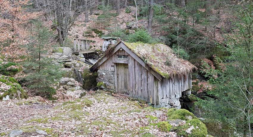
Cool quill grinder along the blue trail
Gyltige, the Svalilt Circuit – BLUE 10 km
The blue trail runs up towards the beautifully located village of Svalilt, passing through both meadows and pastures surrounded by stately beech forests.
On the way to Svalilt you first pass Sutarebo. The trail runs along the edge of Sutarebo Nature Reserve (Swe), External link, opens in new window. a very hilly nature reserve with beech forests and steep ravines. On the land belonging to the village of Örnås, the beech forest becomes less hilly. The beech trees form impressive pillared halls, and when their leaves bud in springtime all of Svalilt shimmers in beautiful light green.
During certain times of year, you can pick various berries, including raspberries, in Svalilt. At almost 200 metres above sea level, the village is one of the highest in Halland. On the highest hills of the village you have a panoramic view of the countryside. Remember to show consideration for the animals grazing in the pastures.
Just east of Svalilt there is an old mill that has been preserved in good condition. It shows how the farmers of yesteryear went about grinding their grain. Feel free to have a look inside the mill and read the posted information about how the mill worked. Håraltasjön lake probably served as a water reservoir, and when the water level became too high, the water was released.
Gyltige, the Håraltsjön Circuit – WHITE 13.2 km
The white trail is the longest hiking trail starting from Gyltige and Simlångsgården. If you choose to go clockwise, the trail first runs along the paved road towards Lidhult, and after a short distance it turns off onto a smaller forest road and then onto a smaller path that heads up towards the village of Håralt.
In Håralt there are several farms. A few kilometres after passing the village, you can glimpse Håraltasjön lake, with both cliffs that plummet steeply into the water and treacherous quagmire floating on top of the water. On a late summer evening, you may well see a moose, the king of the forest, swimming in search of nutritious water lilies. In the past, the lake was used as a reservoir for several small watermills that were located along the stream that flows towards the lake.
The white trail runs through large forests and along the virtually untouched bogs in the
eastern part of Simlångsbygden. Here you can hear - and perhaps even see - both capercaillies and black cocks. In these forests, lynx as well as bears and, of course, moose have been observed at regular intervals. Wild boars also roam these woods, but they are often very timid and difficult to spot. This trail is not yet described on the map above.
Skedala forest
Skedala Forest
Just west of Simlångsdalen lies Skedala Forest. It is a very popular hiking area that offers several different trails in varying degrees of difficulty. The trails range from 3.9 to 7.7 kilometres in length. One of the most popular trails goes around the beautiful Torvsjön lake. Along the trail, there are a number of prepared barbecue facilities that are perfect for a picnic! Bring your own coal. It’s as beautiful here on a summer day as it is on an overcast afternoon when the clouds and fog roll down across Högåsen’s forested heights. Don’t forget to buy a fishing licence and try to catch a pike or rainbow trout while you’re here.
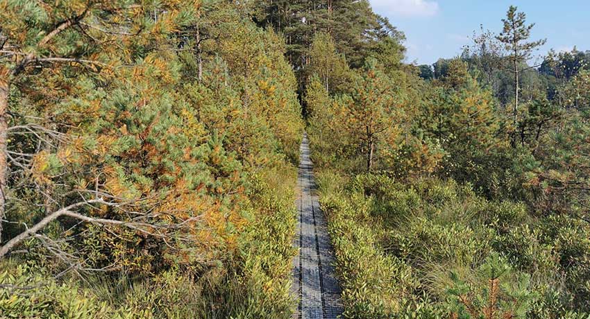
Långhultamyren
Långhultamyren
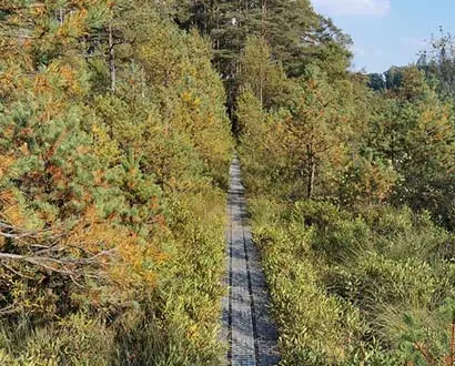
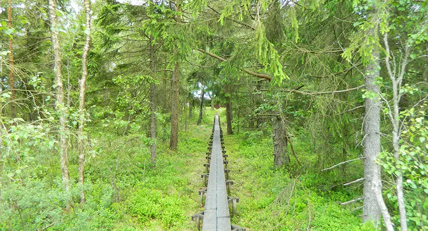
Just before the Småland border is the Långhultamyren nature reserve (Swe). External link, opens in new window. From the parking lot you walk over beautiful juniper slopes, which are reminiscent of the Tuscan landscape on a sunny day. Make sure you wear proper, waterproof shoes when you then trudge out into the mire’s lonely paths. A large part of the trail takes you on footbridges across the mire, but it can still get very damp in places.
In the spring you can experience the beautiful courtship ritual of the black grouse from the cottage which is about one kilometre from the parking lot. There is also an overnight lodging that can accommodate up to four people. In addition to black grouse, you may be lucky enough to see capercaillie and moose or, if you lower your eyes to the ground, cloudberries, cranberries, and the carnivorous plant sundew.
More hiking tips
More Halmstad
-
Inspiration and guides
Can I bring my dog to Halmstad? No problem!… -
Nature and the outdoor life
Ahh! The Halmstad air! Filled with the tangs… -
Beach and coast
Shimmering sea and colorful sunsets are only… -
Food and drink
Food and drink is not just food and drink.… -
Culture and history
In Halmstad we deliver both culture and history… -
Events
Theatre? Concerts? Art exhibitions? Sport?… -
Spa and wellness
Taking an invigorating dip in the sea, lacing… -
Shopping
Shopping is an experience in itself. Perhaps… -
The Swedish capital of golf
153 golf holes, eight unique resorts in a… -
Good to know
We have gathered together a few practical… -
Accommodation
Where would you like to stay? In a castle… -
Sports and activities
Do you like being active? Raising your pulse,…